Bien que l’information sur certains ponts couverts du canton de Potton soit rare, des souvenirs de première main citent le pont Crowell sur la rivière Missisquoi. Ce pont permettait aux résidents de la rive sud de la Missisquoi d’atteindre Dunkin et ses écoles, magasins et forgerons. Réciproquement, la population de la rive nord pouvait atteindre Highwater, où se trouvait la gare de la South Eastern Railway.
Dans un article à propos du hameau de Dunkin, publié dans Yesterdays of Brome County (Volume 3), les auteurs racontent ceci :
« Il y avait un vieux pont en bois appelé le pont Crowell qui traversait la rivière Missisquoi un peu au sud de Dunkin. Il a été utilisé pour transporter des billots de bois grâce à des charrettes tirées par une équipe de quatre chevaux. L’hiver, le transport se faisait sur des traîneaux. Ce type de transport intervient après l’arrêt de l’utilisation par les compagnies forestières de la Missisquoi [pour le flottage du bois]. Les billes étaient déchargées à la glissière Crowell sur le côté sud de la rivière, chargées sur les wagons plats du Canadien Pacifique et expédiées à la Singer Co. à Saint-Jean. Des années plus tard des camions ont été utilisés pour ce transport. Le vieux pont a été reconstruit trois fois et a finalement cédé vers les années 1950. »
Although information about some of the historical covered bridges in Potton Township is scarce, there are published firsthand recollections of the Crowell Bridge over the Missisquoi River. This bridge allowed residents on the south side of the river to reach Dunkin, with its schools, store, blacksmith shops, and other amenities. It also allowed residents on the north side to reach Highwater, where the South Eastern Railway station was located.
In an article about Dunkin in Yesterdays of Brome County (Volume 3), the authors wrote:
“There was an old wooden bridge called the Crowell Bridge that crossed the Missisquoi River a little bit south of Dunkin, and this was used to transport logs by four horse teams using sleighs in winter. This was after the logging companies stopped using the Missisquoi River [for log drives], and the logs or lumber were brought over the old bridge to Crowell’s siding on the south side of the river to the Canadian Pacific Railway where it was loaded on flat cars and shipped to the Singer Co. in St. John’s. In later years trucks were used to transport the logs. The old bridge was rebuilt three times, and it finally broke up in the 1950’s.”
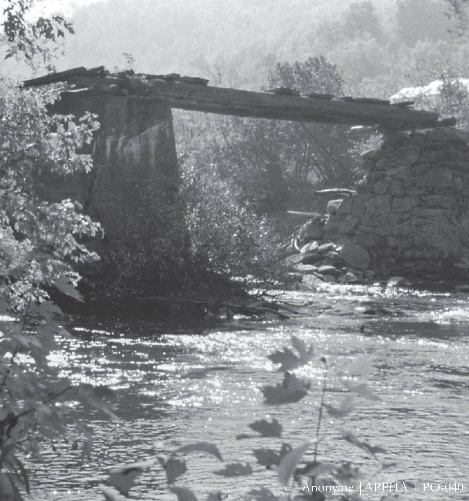
Pont Crowell
Le pont Crowell portait le nom du fermier Fred Crowell qui vivait sur la rive sud de la Missisquoi. Cette photo des ruines du pont date probablement de 1965.
The Crowell Bridge was named after a farmer named Fred Crowell, who lived on the south side of the Missisquoi River. This photo of the bridge ruins is believed to have been taken in 1965 or thereabouts.
Le pont couvert North Branch enjambait la rivière Missisquoi Nord à Meigs Corner, un hameau disparu qui se situait entre Mansonville et Highwater. Long de 22,6 m (74 pi), il a été construit au début des années 1890 pour desservir une ancienne route Montréal-Boston. Il s’est écroulé en 1980.
The North Branch Bridge stood over the North Missisquoi River at Meigs Corner, a hamlet between Mansonville and Highwater that has vanished. It was 22.6 metres (74 feet) in length and was constructed in the early 1890s to serve as part of a route between Montreal and Boston. It collapsed in 1980.
