Géographie du canton de Potton
Le canton de Potton est situé dans les Cantons-de-l'Est, au Québec, et ses dimensions furent établies en un quadrilatère d'environ 16 km (dix milles) de côté. Une carte routière du canton de Potton datant de 1881 est présentée ci-dessus.
Le canton est limité au sud par l’État du Vermont, à l’est par le lac Memphrémagog, au nord par le canton de Bolton et à l’ouest par les monts Sutton. C'est un territoire rural administré par la Municipalité du Canton de Potton, située à Mansonville.
En plus, on y compte plusieurs hameaux dont trois sur les rives du lac Memphrémagog, soit Leadville à la frontière sud, Vale Perkins au centre et Knowlton's Landing près de la frontière nord. Au coin sud-ouest du canton se trouve Dunkin (West Potton) et, au sud, près de la frontière des États-Unis, Mansonville Station, aujourd'hui Highwater.
Geography of Potton Township
Potton Township is located in the Eastern Townships of Quebec and its dimensions were set as a square of about I6km (10 by 10 miles). A road map dated 1881 is presented above.Its border to the south is the State of Vermont, to the east, Lake Memphremagog, to the north, Bolton Township and to the west, the Sutton Mountains. It is a rural territory administered by the Municipality of Potton Township located in Mansonville.
In addition, there are several hamlets on the shores of Lake Memphremagog: Leadville on the southern border, Knowlton's Landing to the north and Vale Perkins in between. At the southwest corner of the Township is Dunkin (formerly West Potton) and near the Border is Highwater (formerly Mansonville Station).
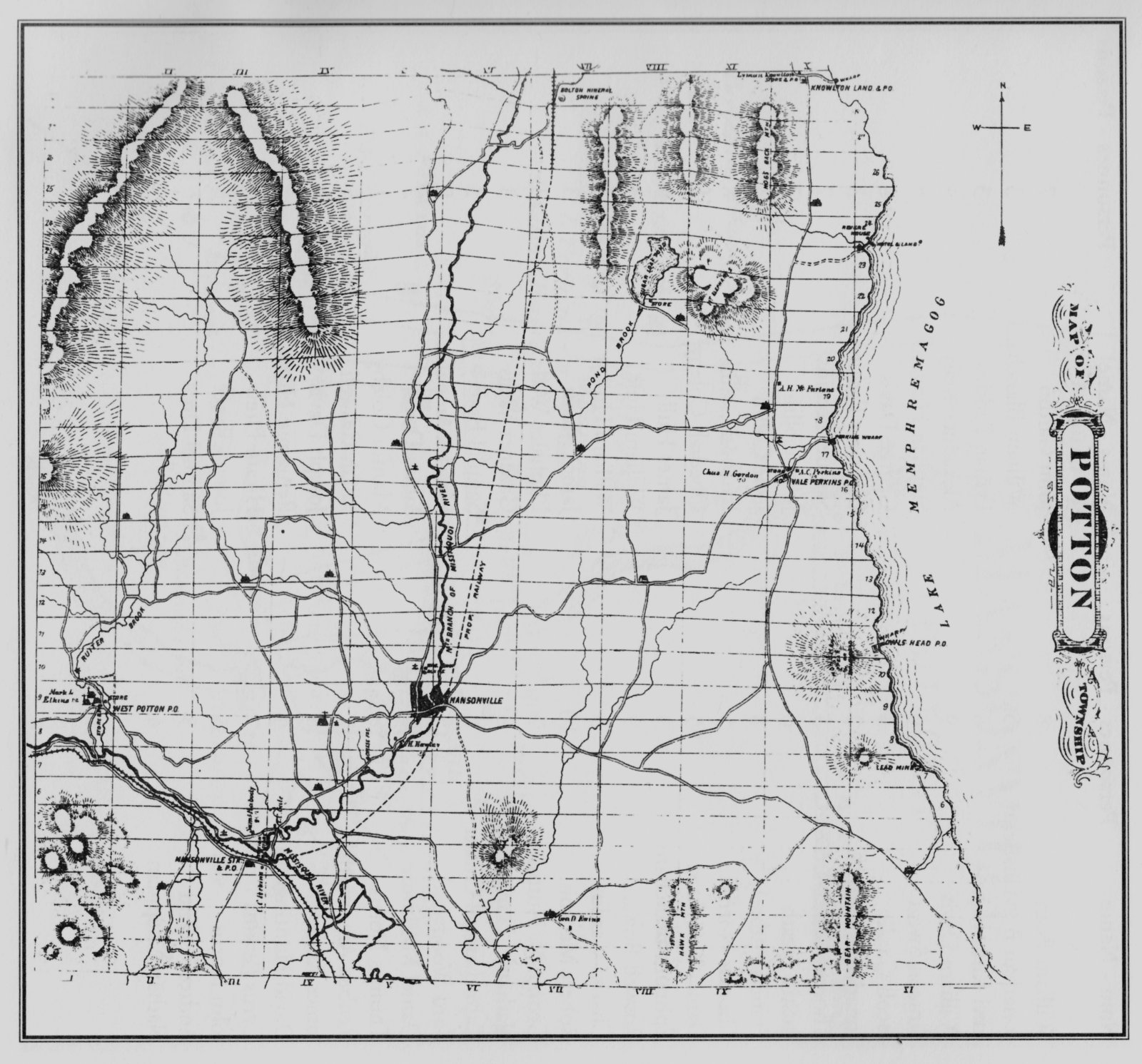
Carte routière du canton de Potton | 1881 | H. Belden & Cie
Le territoire est vaste et montagneux, il se situe dans les contreforts des Appalaches, et est couvert de forêts où prédominent les bois francs. Le lac Memphrémagog est un des éléments naturels marquants du paysage du canton et il joua un rôle déterminant dans son histoire.
À l’intérieur, on compte deux lacs, soit l'Étang Sugar Loaf et l’Étang Fullerton. Ce dernier fut créé vers 1911 par un barrage en maçonnerie. Les principaux cours d'eau sont: la rivière Missisquoi qui traverse le canton du nord au sud, coulant vers le lac Champlain, le Mud Creek qui se jette dans la Missisquoi Sud et, enfin, le ruisseau Ruiter, un affluent de la Missisquoi qui prend sa source dans le bassin de drainage de l'Étang Fullerton.
Pour revenir à la rivière Missisquoi, une carte de l’État de New York de 1779 donne le nom de "Deep Still wr" probablement pour indiquer une rivière au cours profond et tranquille. Ce n'est pas tout à fait le cas quand on connaît les rapides de Bolton et la chute de Mansonville; en été, l’eau est loin d'être profonde. Le nom de la branche sud de la rivière donné sur cette carte est "Missiskoui", un nom d'origine autochtone.
Le canton de Potton fut une région agricole très active, axée principalement sur l'industrie laitière, et, bien que réduites aujourd'hui, les bonnes terres sont encore exploitées. On retrouve donc un paysage varié qui comporte de vastes vallées et des montagnes pittoresques.
The landscape is a hilly extension of the Appalachian mountains with a hardwood forest cover. Lake Memphremagog is one of the dominant natural features of the landscape and had a determining role in the history of Potton.
In the interior there are two small lakes, Sugar Loaf Pond and Fullerton Pond. The latter is an impoundment held by a masonry dam built around 1911 and therefore does not appear on the 1881 map. The three major streams are the Missisquoi River which crosses the Township from North to South as it flows towards Lake Champlain, Ruiter Brook which runs into the Missisquoi taking its source in Fullerton Pond and, finally, Mud Creek which flows into the south branch of the Missisquoi.
A map of New York State dated 1779 calls the Missisquoi "Deep Still wr" (water) probably indicating a deep river with quiet waters. It is far from the truth when one knows the rapids in Bolton and in Mansonville and the very shallow stretches during the summer months. Missiskoui, a name most likely of Native origin, labels the southern branch on that map.
There was a very active agricultural life in Potton, mostly with dairy production, which is much less active today. Fertile land is still farmed and one can enjoy a varied landscape dominated with vast open valleys and scenic mountains.