Covered Bridges
The first covered bridges were built in Asia and Europe, some dating from the 12th and 13th centuries. An American engineer, Timothy Palmer, from Newburyport Massachusetts, built in 1797 the first covered bridge in North America.
From the mid-1800s until 1958, more than 1000 covered bridges, inspired by the New England model, were built in Quebec. Of these, 245 remained in 1965, but only 88 were standing in 2005. Wooden bridges, left unprotected from rot and weather related deterioration generally lasted less than 15 years; however those protected by walls and roof could be used for decades more. Inclement weather, floods, ice jams, fires, wear and tear and overloading eventually led to the demise of this type of construction.
An inconvenience to covered bridge use in winter was the necessity for its road deck to be covered in snow, in order to permit the metal runners of horse drawn sleds to slide on the bridge surface without gouging into it.
The first covered bridges were privately owned, often built by farmers or local merchants and for the most part, users paid a toll to pass and were liable for any damages caused to the structure.
From 1900 to 1930, covered bridges declined in popularity. Later, the Provincial and Municipal governments of the time began to build covered bridges to increase settlements for reasons of economic expansion and to lessen unemployment rates of the day.
Bridges built during these times often bore names like “Colony Bridge”, “Settlement Bridge” or “Depression Bridge".
Covered bridges were an essential part of the roads network at one time and their walls were often used for publicity purposes to post announcements, sales, auctions, community events and activities, public meetings and the like.
Covered bridges also served as the inspiration for local lore and legend — tales of phantom horseman gal loping wildly across the span, treasure buried beneath the bridge, robbery by highwaymen, or ghostly encounters with the widow in black who wanders the bridges.
Nonetheless, what perfect meeting places a covered bridge provided for stolen kisses and surreptitious embrace!
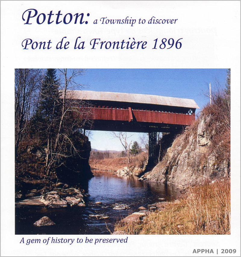
Pont de la Frontière
The Pont de la Frontière was built in 1896, near the northern border of the State of Vermont (frontière in the French language means "border" or "boundary", hence its name). Of simple Town design and construction, the Pont de la Frontière was retired from use in 1960 after more than 75 years of loyal service. Its official name Pont de la Frontière came on July 2, 1991 by resolution of the Municipal Council of the Township of Potton, following the recommendation of the Société des ponts couverts du Québec. At first it was simply known as the Creek Bridge, after Mud Creek, the common name for the brook the bridge spans. From 1983 to 1991, it was officially known as the Province Hill Bridge, and this is still its local appellation for many people. No matter what its name, our grand old Pont de la Frontière has had an exceptional life span of some 114 years to 2010.
The Pont de la Frontière is found on Chemin Bellevue, where it spans a deep gorge on the Mud Brook. A walking trail was once located upstream from the bridge beginning near the Province Hill Cemetery, on the road of the same name, and led to the brook side — where a splendid view of the bridge was to be seen. The bridge measures a total of 31.04 meters (101 feet,10 inches) and its overall width is 4.95 meters (16 feet, 3 inches). The road deck measures 4.04 meters (13 feet, 3 inches). The total span of the Pont de la Frontière is one of the longest in Québec, high above the dangers of spring flooding.
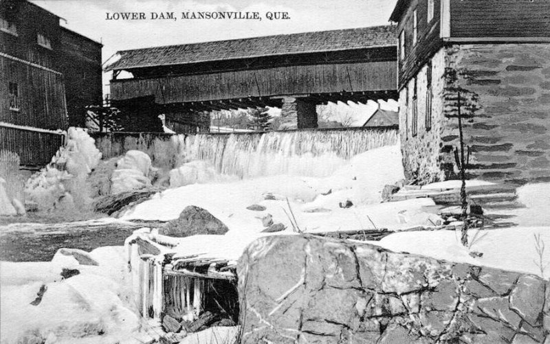
Mansonville Covered Bridge
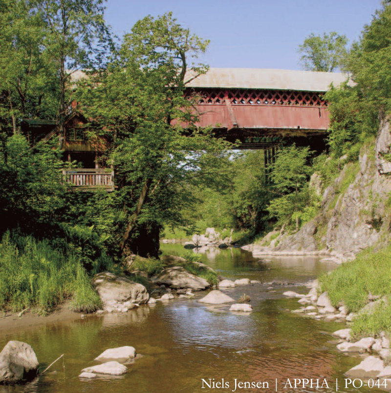
View from Mud Brook
On October 6, 2008, the Pont de la Frontière was designated a historic monument by the Municipal Council of the Township of Potton. [See Note]
Potton once had two other covered bridges, now long since absent from our landscape. One of these was located in the village of Mansonville. It was destroyed in a flood, and replaced by a concrete structure.
The other was located at Highwater. Only two covered bridges remain in the MRC of Memphrémagog, the other being the Narrows Bridge in Fitch Bay, Township of Stanstead. Ten covered bridges remain throughout the entire Eastern Townships area.
Note
This designation was cancelled in 2023, but the Ministère de la Culture et des Communications du Québec classified the covered bridge in the fall of 2024.
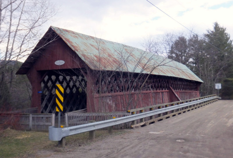
The Anatomy of a Covered Bridge
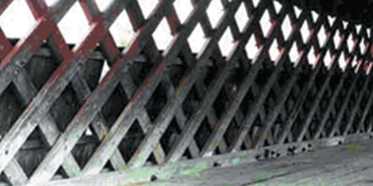
A covered bridge is a bridge constructed of wood, often cedar. The bridge is composed of a road deck supported by trusses or beams. Exterior sheathing protects the structure and a roof covers it.
The Pont de la Frontière is of the simple Town style, comprised of diagonally set planks pegged into a crisscrossing pattern, secured by top and bottom chords and covered with a roof. Exterior sheathing protects the structure. The lattice openings above the sheathing are more functional than aesthetic. The openings provide natural light, ventilation, and serve to dissipate noise, which was important during the era of travel and transport by horse. Darkness and the thunderous echo of hooves clattering in the hollow somberness of a long bridge span often spooked horses.
The elements of a bridge foundation were generally pillar-like pilings composed of wood cribbing. Some bridges rested on laid-up stone or masonry foundations. Over time, most of these foundations were rebuilt or simply faced with concrete.
Triangulated Beams of Simple Town Type
Among the characteristics of the Pont de la Frontière are the diagonally placed planks forming an open lattice pattern, the buttressing at mid-span, the vertical sheathing, the extended eaves, the wide lateral opening and straight line lintel at each portico. Substantial bedrock at either side of the brook eased construction requirements for sturdy foundation pilings. The Pont de la Frontière is classified in 6th position, with a heritage indicator of 88%, amongst the covered bridges of Quebec.
Sources
- Arbour, Gérard, Fernand Caron and Jean Lefrançois, Les ponts couverts au Québec, published by Les publications du Québec, in 2005. See pages 111-113, 180, 185, 199 of this book. Ministère des Transports du Québec.
- La Société d’histoire des Cantons de l’Est
- La Société des ponts couverts du Québec
- Photographs: Édith Smeesters, Hans Walser, Archival records of the Potton Heritage Association, Ministère des Transports du Québec
Production team
Research and English text: Sandra Jewett
Research and French text: Jean-Louis Bertrand
Printed edition © 2009
Web edition: Serge Normand, 2024
Web edition revision: Jacqueline Robitaille, 2025